1. Home
  2. Cities
List
Map
Timeline
Routes
Stories

Tavira

Torre de Aires

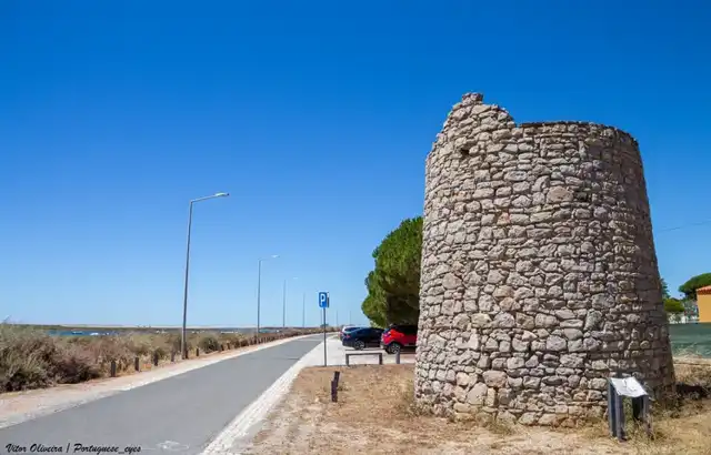
Under the fields lies Balsa, the Roman town; the tower came later and was left standing on top of it.
Torre de Aires

Periods

RomanIslamicMedievalRenaissance

Tags

Photography SpotsScenic ViewGuided ToursMoorishRomanMaritime History

Opening hours

Freely accessible The site is in the public space and can be visited at any time.

Website

https://cm-tavira.pt/site/conhecer-tavira/luz-de-tavira/

Introduction

The round tower on the hill is three metres tall and the only thing you can see. What you are standing on is bigger. Under the fields around the tower lies Balsa, the Roman town that Pliny and Ptolemy mention, and which struck its own coins before Tavira existed. People lived here from the 1st century BC until the 600s. The tower came later and was left standing on top of the town. Its date is a guess, probably the Islamic period; what is certain is that it belonged to the chain of coastal towers that warned of Barbary pirates with smoke by day and fire by night. Stone outside, rammed earth inside, cut down. The parish's five other towers are gone.

Historical highlights

Balsa, the town under the fields

Balsa was the Roman town on this coast. Mela, Pliny and Ptolemy mention it, and it was striking coins as early as the 1st century BC. Its heyday was short, the 1st and 2nd centuries; after that it went downhill, and by the 600s the place had been abandoned. The town centre lay on the hill where Quinta da Torre de Aires is today, on an artificial platform, probably the forum. At Quinta das Antas, fish-salting tanks have been excavated. Everything lies beneath the plough layer.

The tower on top of the town

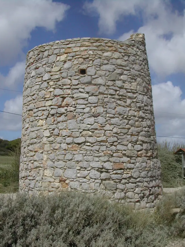
The tower is round, slightly conical, about three metres tall. The shell is irregular stone set in mortar, the core rammed earth, taipa. When it was built, nobody knows. The official register calls it Islamic, somewhere between the 700s and the 1200s, and itself writes "conjectural". The story of the tower guarding the Roman town is better. The town was simply deserted when the tower was raised, whichever century you pick.

Smoke by day, fire by night

What the tower certainly did was keep watch. It was part of a long line of towers along the coast that warned the population when Barbary pirates from North Africa came ashore. By day with columns of smoke, by night with fire. According to a description from the 1500s, the coast was watched day and night in summer. The name dates from the same period: Aires Gonçalves owned the land and was still alive in 1617.

Six towers, one left

In 1758 the parish priest Vicente Nunes Leal wrote about the parish's towers. There had been "seis torres feitas à antiga, com muita altura", six towers built in the old way and very tall. Three collapsed in the earthquake of 1 November 1755, of two others only traces remained, and one was left standing, Torre de Aires Gonçalves, and it had been cut down. When and why, he does not say. In 1996 the tower was about to collapse completely and was consolidated. The top was levelled, apart from a small projection left standing to show that the tower had been taller. In 2008 the surroundings and the promenade followed.

Practical

The tower is municipal property and stands on its own in the Ria Formosa nature park, by the promenade from 2008. Look at the masonry: stone in mortar outside, rammed earth inside. The projection on top is not decay, it was left there on purpose. Balsa lies under the cultivated fields around it, on private land, and there is nothing of the town to see on the ground. The finds were shown at Palácio da Galeria in Tavira in 2024-25; the catalogue is called "Balsa, Cidade Romana".

Timeline and context

Timeline

  • 1st c. BC Balsa strikes its own coins; the earliest evidence of the name.
  • 1st-2nd c. Heyday; Latin rights under Vespasian; fish salting at Quinta das Antas.
  • 3rd-7th c. Decline; the place is abandoned by the 600s at the latest.
  • 700s-1200s The tower is raised, probably in the Islamic period; a guess.
  • Late 1500s The name Torre de Aires, after the landowner Aires Gonçalves.
  • 1755 The earthquake brings down three of the parish's six towers; in 1758 only this one is standing, cut down.
  • 1866 Estácio da Veiga identifies Balsa with the farms at Torre d'Ares.
  • 1978 A bulldozer goes through the ruins.
  • 1992 Part of Balsa is protected as Imóvel de Interesse Público.
  • 1996 The tower is consolidated, the top levelled; surroundings and promenade 2008.
  • 2019-22 Universidade do Algarve excavates; the town's boundaries are established.
  • 2024-25 The exhibition "Balsa, Cidade Romana" at Palácio da Galeria.

Why the town was here

Balsa lay by the lagoon on the road along the coast, 16 Roman miles from Ossonoba and about 24 from Besuris at Castro Marim. The lagoon gave fish and salt, and salted fish was what the town lived on. The archaeologists place the town centre on the hill where Quinta da Torre de Aires stands, with an artificial platform that probably carried the forum. Many hundreds of years later someone raised a watchtower on the same hill. That is hardly a coincidence. The hill that was good for a forum was also good for spotting pirates from.

What is left

Of the tower: three metres. Of the town: almost nothing above ground. The land is private and has been farmed hard since the mid-1900s, a bulldozer went through the ruins in 1978, and in 2015 strawberry greenhouses on the site were stopped. Most of what is known about Balsa's layout comes from geomagnetics and ground-penetrating radar since 2017, not from the spade. It has shown that the town was much smaller than was thought; what was taken for town was villas around it. The place is more interesting than it looks. The tower is here because it was left standing. The town, because most of it has never been dug up.
Additional research material is available for this site.

Torre de Aires

Torre de Aires - site.siteImage 1/2
Torre de Aires - CorreiaPM, Public domain, via Wikimedia Commons 2/2
©CorreiaPM, Public domain, via Wikimedia Commons (2005)
Torre de Aires
Show on map
Photography SpotsScenic ViewGuided ToursMoorishRomanMaritime History

Introduction

The round tower on the hill is three metres tall and the only thing you can see. What you are standing on is bigger. Under the fields around the tower lies Balsa, the Roman town that Pliny and Ptolemy mention, and which struck its own coins before Tavira existed. People lived here from the 1st century BC until the 600s. The tower came later and was left standing on top of the town. Its date is a guess, probably the Islamic period; what is certain is that it belonged to the chain of coastal towers that warned of Barbary pirates with smoke by day and fire by night. Stone outside, rammed earth inside, cut down. The parish's five other towers are gone.

Research

Historical highlights

Balsa, the town under the fields

Balsa was the Roman town on this coast. Mela, Pliny and Ptolemy mention it, and it was striking coins as early as the 1st century BC. Its heyday was short, the 1st and 2nd centuries; after that it went downhill, and by the 600s the place had been abandoned. The town centre lay on the hill where Quinta da Torre de Aires is today, on an artificial platform, probably the forum. At Quinta das Antas, fish-salting tanks have been excavated. Everything lies beneath the plough layer.

The tower on top of the town

The tower is round, slightly conical, about three metres tall. The shell is irregular stone set in mortar, the core rammed earth, taipa. When it was built, nobody knows. The official register calls it Islamic, somewhere between the 700s and the 1200s, and itself writes "conjectural". The story of the tower guarding the Roman town is better. The town was simply deserted when the tower was raised, whichever century you pick.

Smoke by day, fire by night

What the tower certainly did was keep watch. It was part of a long line of towers along the coast that warned the population when Barbary pirates from North Africa came ashore. By day with columns of smoke, by night with fire. According to a description from the 1500s, the coast was watched day and night in summer. The name dates from the same period: Aires Gonçalves owned the land and was still alive in 1617.

Six towers, one left

In 1758 the parish priest Vicente Nunes Leal wrote about the parish's towers. There had been "seis torres feitas à antiga, com muita altura", six towers built in the old way and very tall. Three collapsed in the earthquake of 1 November 1755, of two others only traces remained, and one was left standing, Torre de Aires Gonçalves, and it had been cut down. When and why, he does not say. In 1996 the tower was about to collapse completely and was consolidated. The top was levelled, apart from a small projection left standing to show that the tower had been taller. In 2008 the surroundings and the promenade followed.

Practical

The tower is municipal property and stands on its own in the Ria Formosa nature park, by the promenade from 2008. Look at the masonry: stone in mortar outside, rammed earth inside. The projection on top is not decay, it was left there on purpose. Balsa lies under the cultivated fields around it, on private land, and there is nothing of the town to see on the ground. The finds were shown at Palácio da Galeria in Tavira in 2024-25; the catalogue is called "Balsa, Cidade Romana".

Research

Timeline and context

Timeline

  • 1st c. BC Balsa strikes its own coins; the earliest evidence of the name.
  • 1st-2nd c. Heyday; Latin rights under Vespasian; fish salting at Quinta das Antas.
  • 3rd-7th c. Decline; the place is abandoned by the 600s at the latest.
  • 700s-1200s The tower is raised, probably in the Islamic period; a guess.
  • Late 1500s The name Torre de Aires, after the landowner Aires Gonçalves.
  • 1755 The earthquake brings down three of the parish's six towers; in 1758 only this one is standing, cut down.
  • 1866 Estácio da Veiga identifies Balsa with the farms at Torre d'Ares.
  • 1978 A bulldozer goes through the ruins.
  • 1992 Part of Balsa is protected as Imóvel de Interesse Público.
  • 1996 The tower is consolidated, the top levelled; surroundings and promenade 2008.
  • 2019-22 Universidade do Algarve excavates; the town's boundaries are established.
  • 2024-25 The exhibition "Balsa, Cidade Romana" at Palácio da Galeria.

Why the town was here

Balsa lay by the lagoon on the road along the coast, 16 Roman miles from Ossonoba and about 24 from Besuris at Castro Marim. The lagoon gave fish and salt, and salted fish was what the town lived on. The archaeologists place the town centre on the hill where Quinta da Torre de Aires stands, with an artificial platform that probably carried the forum. Many hundreds of years later someone raised a watchtower on the same hill. That is hardly a coincidence. The hill that was good for a forum was also good for spotting pirates from.

What is left

Of the tower: three metres. Of the town: almost nothing above ground. The land is private and has been farmed hard since the mid-1900s, a bulldozer went through the ruins in 1978, and in 2015 strawberry greenhouses on the site were stopped. Most of what is known about Balsa's layout comes from geomagnetics and ground-penetrating radar since 2017, not from the spade. It has shown that the town was much smaller than was thought; what was taken for town was villas around it. The place is more interesting than it looks. The tower is here because it was left standing. The town, because most of it has never been dug up.

Research

AI-generated content

The text and narration were created with artificial intelligence — the voice is synthetic. The content is reviewed editorially, but errors may occur.