1. Home
  2. Cities
List
Map
Timeline
Routes
Stories

Tavira

Cacela Velha

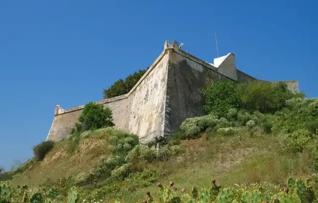
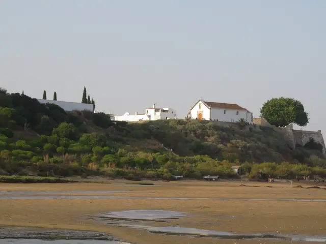
Church, fort and white houses on the cliff above the Ria Formosa, east of Tavira.
<a href="//commons.wikimedia.org/wiki/User:MJJR" title="User:MJJR">Marc Ryckaert</a>
© Marc Ryckaert (2007)

Periods

IslamicMedievalRenaissance

Tags

Photography SpotsScenic ViewCastleChurchMoorishMyths & LegendsIslamic HeritageMaritime History

Opening hours

Freely accessible The site is in the public space and can be visited at any time.

Wikipedia

Read more on Wikipedia

Introduction

Cacela Velha is about 50 inhabitants, a church, a fort and a few white houses on a cliff above the easternmost inlet of the Ria Formosa. The village lies east of Tavira, in the municipality of Vila Real de Santo António, and the streets have neither names nor house numbers. It was once more than that. Under the Moors the place was called Qastalla Darraj and was the seat of a district; in the 1100s the geographer al-Idrīsī called it a fortress by the sea, well populated and with many gardens and fig orchards. Later the town got its own charter, its own comendador and its own town hall, and lost it all again. It just never got remodelled. That is why it is worth the drive out.

Historical highlights

Qastalla Darraj

In the Arabic sources the place is called Qastalla Darraj, from the 900s the seat of a district in the province of Ossónoba. In the early 1100s al-Idrīsī wrote of "a fortress built by the sea", well populated, with gardens and fig orchards. The castle was square, about 40 metres on each side, and in 1168 the Almohads' base for the conquest of Tavira. Excavations led by Cristina Garcia have found the town: east of the village a residential quarter from the 1200s along a street with a sewer, and by the fort square probably the judge's house and five grain silos. The house was razed in the Christian conquest.

The Order of Santiago's town

In 1240 Sancho II took Cacela and gave it to the Order of Santiago and Paio Peres Correia. The Moors took it back, and Correia conquered it again in 1242. D. Dinis gave the town a foral in 1283. Another version, Magalhães' from 2012, says the Almohads of Silves exchanged Cacela for Estômbar and Alvor in 1238. The town never grew large. In 1465 there were no houses outside the castle, where the comendador lived, and in 1548 he wrote to the king that Moorish privateers were heading for the coast and asked for permission to keep a coastal watch.

Church and fort

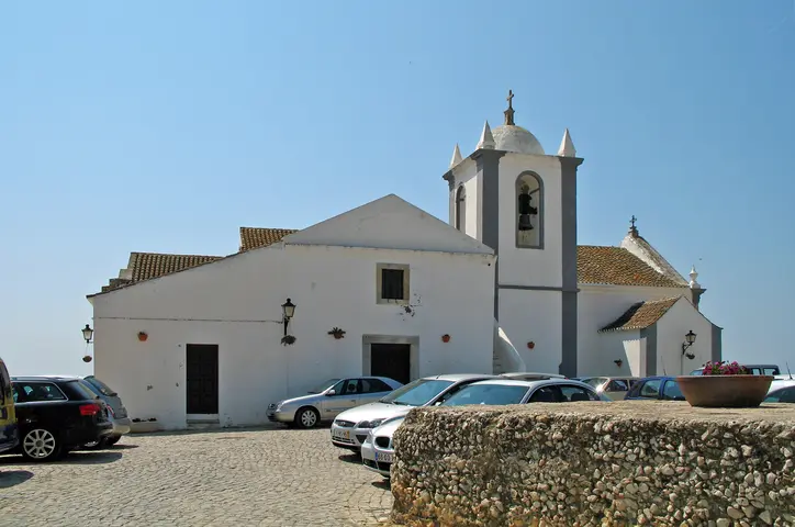
The church of Nossa Senhora da Assunção has a core from the mid-1200s, but the only visible part from that time is the pointed-arched north portal. The rest is a Renaissance rebuilding from 1518, attributed to André Pilarte: three naves, columns with ball capitals and a portal with busts of Peter and Paul. The fort dates from the time of D. João III and D. Sebastião; in 1565 it was square with a tower at each corner. In 1617 the engineer Massai found the castle in ruins and the town without inhabitants and proposed demolishing it and abolishing the town.

Earthquake and rebuilding

On 1 November 1755 the church, the Misericórdia and the town hall collapsed, and the fort's bastions fell so violently that the cannons ended up on the beach, a contemporary account says. In 1770 governor D. Rodrigo de Noronha had the fort rebuilt with a lighthouse, completed in 1794; the plan is square with two half-bastions facing the sea, not star-shaped as is often stated. Bishop Avelar had the church repaired around 1795. In 1774 or 1775 the municipality of Cacela was abolished in favour of the newly founded Vila Real de Santo António. Listed in 1996.

Practical

The fort is inhabited and closed to the public. The church was reopened in August 2010; look for the Gothic north portal and the busts of Peter and Paul on the main portal. Above the fort's gate is the inscription from 1794. Sophia de Mello Breyner Andresen's poem "A conquista de Cacela" from 1962 is displayed on azulejo tiles in the village. The cistern on the square rests on house walls from the 1300s. In July the village holds the festival Noites da Moura Encantada, named after the legends of enchanted Moorish women.

Timeline and context

Timeline

  • 900s Qastalla Darraj is mentioned as the seat of an iqlīm in the province of Ossónoba.
  • Early 1100s al-Idrīsī describes a fortress by the sea with fig orchards.
  • 1168 The Almohads use the castle as a base for the conquest of Tavira.
  • 1240 Sancho II conquers Cacela and gives it to the Order of Santiago; reconquered in 1242.
  • 1283 D. Dinis grants the town a foral on 17 July.
  • 1465 Severe depopulation; no houses outside the castle.
  • 1518 The Renaissance rebuilding of the church begins.
  • 1565 Visitation: the fort is square with a tower at each corner.
  • 1617 Massai finds the castle in ruins and the town without inhabitants.
  • 1755 The earthquake destroys the church, the town hall and the fort's bastions.
  • 1770-94 The fort is rebuilt with a lighthouse; the church is repaired around 1795.
  • 1774/75 The municipality of Cacela is abolished in favour of Vila Real de Santo António.
  • 1996 The village is listed as Imóvel de Interesse Público.
  • 1998-2007 Excavations uncover the Almohad quarter.

Why the village is here

The cliff rises 26 metres above the easternmost inlet of the Ria Formosa, or 67, depending on which listing record you read, and from here you see everything that sails in and out. Hence a district seat under the Moors and the Almohads' base against Tavira in 1168, and hence a new fort in the 1500s, when Moorish privateers lay off the coast. Every time the threat disappeared, so did the reason to live here. Depopulated in 1465, without inhabitants in 1617, the municipality abolished in 1775. A lookout post made redundant several times over.

What remains

The street grid from the Middle Ages and the 1500s is preserved, the listing record says, and that is what you walk around in. The fort from 1770-94 is inhabited and closed. The church is 1518, with a Gothic door on the north side. Beneath the ground lies the Islamic town. Cacela Velha has not been restored for tourists. It simply has not been remodelled since the 1700s, and the difference shows, especially if you come from Vila Real de Santo António, the town that took its town hall.
Additional research material is available for this site.

Cacela Velha

Cacela Velha - <a href="//commons.wikimedia.org/wiki/User:MJJR" title="User:MJJR">Marc Ryckaert</a>
 1/4
©Marc Ryckaert (2007)
Cacela Velha - <a href="//commons.wikimedia.org/w/index.php?title=User:Mpicado&amp;action=edit&amp;redlink=1" class="new" title="User:Mpicado (page does not exist)">Mpicado</a>
 2/4
©Mpicado (2020)
Cacela Velha - <a href="//commons.wikimedia.org/wiki/User:MJJR" title="User:MJJR">Marc Ryckaert</a>
 3/4
©Marc Ryckaert (2020)
Cacela Velha - <a href="//commons.wikimedia.org/wiki/User:Xabier_Ca%C3%B1as" title="User:Xabier Cañas">Xabier Cañas</a>
 4/4
©Xabier Cañas (2021)
Cacela Velha
WikipediaShow on map
Photography SpotsScenic ViewCastleChurchMoorishMyths & LegendsIslamic HeritageMaritime History

Introduction

Cacela Velha is about 50 inhabitants, a church, a fort and a few white houses on a cliff above the easternmost inlet of the Ria Formosa. The village lies east of Tavira, in the municipality of Vila Real de Santo António, and the streets have neither names nor house numbers. It was once more than that. Under the Moors the place was called Qastalla Darraj and was the seat of a district; in the 1100s the geographer al-Idrīsī called it a fortress by the sea, well populated and with many gardens and fig orchards. Later the town got its own charter, its own comendador and its own town hall, and lost it all again. It just never got remodelled. That is why it is worth the drive out.

Research

Historical highlights

Qastalla Darraj

In the Arabic sources the place is called Qastalla Darraj, from the 900s the seat of a district in the province of Ossónoba. In the early 1100s al-Idrīsī wrote of "a fortress built by the sea", well populated, with gardens and fig orchards. The castle was square, about 40 metres on each side, and in 1168 the Almohads' base for the conquest of Tavira. Excavations led by Cristina Garcia have found the town: east of the village a residential quarter from the 1200s along a street with a sewer, and by the fort square probably the judge's house and five grain silos. The house was razed in the Christian conquest.

The Order of Santiago's town

In 1240 Sancho II took Cacela and gave it to the Order of Santiago and Paio Peres Correia. The Moors took it back, and Correia conquered it again in 1242. D. Dinis gave the town a foral in 1283. Another version, Magalhães' from 2012, says the Almohads of Silves exchanged Cacela for Estômbar and Alvor in 1238. The town never grew large. In 1465 there were no houses outside the castle, where the comendador lived, and in 1548 he wrote to the king that Moorish privateers were heading for the coast and asked for permission to keep a coastal watch.

Church and fort

The church of Nossa Senhora da Assunção has a core from the mid-1200s, but the only visible part from that time is the pointed-arched north portal. The rest is a Renaissance rebuilding from 1518, attributed to André Pilarte: three naves, columns with ball capitals and a portal with busts of Peter and Paul. The fort dates from the time of D. João III and D. Sebastião; in 1565 it was square with a tower at each corner. In 1617 the engineer Massai found the castle in ruins and the town without inhabitants and proposed demolishing it and abolishing the town.

Earthquake and rebuilding

On 1 November 1755 the church, the Misericórdia and the town hall collapsed, and the fort's bastions fell so violently that the cannons ended up on the beach, a contemporary account says. In 1770 governor D. Rodrigo de Noronha had the fort rebuilt with a lighthouse, completed in 1794; the plan is square with two half-bastions facing the sea, not star-shaped as is often stated. Bishop Avelar had the church repaired around 1795. In 1774 or 1775 the municipality of Cacela was abolished in favour of the newly founded Vila Real de Santo António. Listed in 1996.

Practical

The fort is inhabited and closed to the public. The church was reopened in August 2010; look for the Gothic north portal and the busts of Peter and Paul on the main portal. Above the fort's gate is the inscription from 1794. Sophia de Mello Breyner Andresen's poem "A conquista de Cacela" from 1962 is displayed on azulejo tiles in the village. The cistern on the square rests on house walls from the 1300s. In July the village holds the festival Noites da Moura Encantada, named after the legends of enchanted Moorish women.

Research

Timeline and context

Timeline

  • 900s Qastalla Darraj is mentioned as the seat of an iqlīm in the province of Ossónoba.
  • Early 1100s al-Idrīsī describes a fortress by the sea with fig orchards.
  • 1168 The Almohads use the castle as a base for the conquest of Tavira.
  • 1240 Sancho II conquers Cacela and gives it to the Order of Santiago; reconquered in 1242.
  • 1283 D. Dinis grants the town a foral on 17 July.
  • 1465 Severe depopulation; no houses outside the castle.
  • 1518 The Renaissance rebuilding of the church begins.
  • 1565 Visitation: the fort is square with a tower at each corner.
  • 1617 Massai finds the castle in ruins and the town without inhabitants.
  • 1755 The earthquake destroys the church, the town hall and the fort's bastions.
  • 1770-94 The fort is rebuilt with a lighthouse; the church is repaired around 1795.
  • 1774/75 The municipality of Cacela is abolished in favour of Vila Real de Santo António.
  • 1996 The village is listed as Imóvel de Interesse Público.
  • 1998-2007 Excavations uncover the Almohad quarter.

Why the village is here

The cliff rises 26 metres above the easternmost inlet of the Ria Formosa, or 67, depending on which listing record you read, and from here you see everything that sails in and out. Hence a district seat under the Moors and the Almohads' base against Tavira in 1168, and hence a new fort in the 1500s, when Moorish privateers lay off the coast. Every time the threat disappeared, so did the reason to live here. Depopulated in 1465, without inhabitants in 1617, the municipality abolished in 1775. A lookout post made redundant several times over.

What remains

The street grid from the Middle Ages and the 1500s is preserved, the listing record says, and that is what you walk around in. The fort from 1770-94 is inhabited and closed. The church is 1518, with a Gothic door on the north side. Beneath the ground lies the Islamic town. Cacela Velha has not been restored for tourists. It simply has not been remodelled since the 1700s, and the difference shows, especially if you come from Vila Real de Santo António, the town that took its town hall.
Research

AI-generated content

The text and narration were created with artificial intelligence — the voice is synthetic. The content is reviewed editorially, but errors may occur.